A simple tool to share up-to-date project data between the trailer and the field
DENVER, May 19, 2020 /PRNewswire/ -- On May 19 2020, Propeller, a global leader in 3D mapping and drone data analytics solutions, announced a Propeller Platform add-on called Crew, a simple, data sharing tool that worksites use to relay interactive maps from desktops in office to mobile devices in the field.
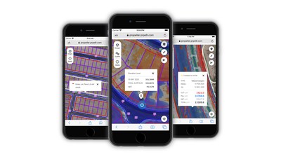
The new add-on gives office teams the power to create and share interactive maps with professionals in the field using one-off links designed for mobile viewing. Each map has a unique URL that can be shared with anyone and any device.
This data sharing tool is designed to unify long-standing information silos with ongoing and open communication. Historically, worksites have manually prepared paper maps to keep site-based crews informed, but these maps quickly become outdated and require a specialist's knowledge to create.
Working from outdated documents, foremen and surveyors on the ground are left to make critical decisions based on guesswork—a recipe for rework and utility strikes. Crew's up-to-date visuals, readily available for viewing on any mobile device, give on-site personnel the confidence they need to make decisions and the power to prevent costly mistakes.
With the Crew add-on, users can:
The best part of the new add-on is its simplicity: it distributes information without requiring users to download an app or remember sign-on credentials.
Engaging with these maps also requires little or no technical knowledge. Office-based personnel just navigate to the site they'd like to share in the Propeller Platform, generate a unique URL, and send it to their in-field team using SMS, email, or any other communication tool they'd like.
After opening the link, crew members can immediately explore a geographically accurate overview of where they're at to spot-check elevations, view volumes, stay safe, and stay informed.
By marrying maps and mobile capabilities, the Crew add-on makes collaboration an effortless part of your workflow— a single link that keeps everyone on your team connected.
About Propeller: Propeller is a global leader in 3D mapping and data analytics solutions that give worksites the power to track, map, and measure their earthwork projects. Propeller's innovative hardware and software products solve real problems for real people. With visual tools everyone can use, Propeller is helping teams on thousands of worksites track, inspect, and report on job progress and productivity safely and accurately.
For media inquiries, please contact Bri Ivar at bri@propelleraero.com.
Photo - https://mma.prnewswire.com/media/1169777/Crew_Maps.jpg
Logo - https://mma.prnewswire.com/media/776726/Propeller_Logo.jpg